Geography
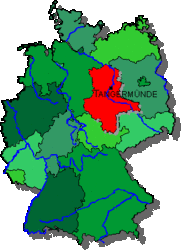
On this page you willfind all the necessary geographical information about the city Tangermünde like the location, major transport links, distances to major cities and parking areas in the city. In order to obtain facts about the river "Elbe", or to get facts about the water level, please click here
Short information
Geographical Position:
29°38'28" eastern longitude
52°32'37" northern latitude
Town area:
22.004.954 sqm
Population:
ca. 10.500
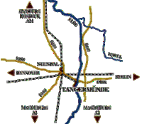
Transport Links
roads:
- A2 Hannover-Berlin
45 km to the direction of Berlin
60 km to the direction of Hannover - B188 Hannover-Berlin passes Tangermünde
- 10 km to the B189 Rostock-Magdeburg
- 3 km to the B107 Rostock-Chemnitz
rail:
- links to the railway junction of Stendal
(about 10 km).
- ICE (fast train) - station at Stendal on the Hannover-Berlin-Line
river:
- River Elbe with harbour
Air:
- 20 km to the business airport Stendal-Borstel
distance to:
Berlin approx. 120 km
Hamburg approx. 240 km
Hannover approx. 190 km
carparks:
Tanger carpark -- for cars, coaches and caravans
Harbour carpark -- cars and coaches only


